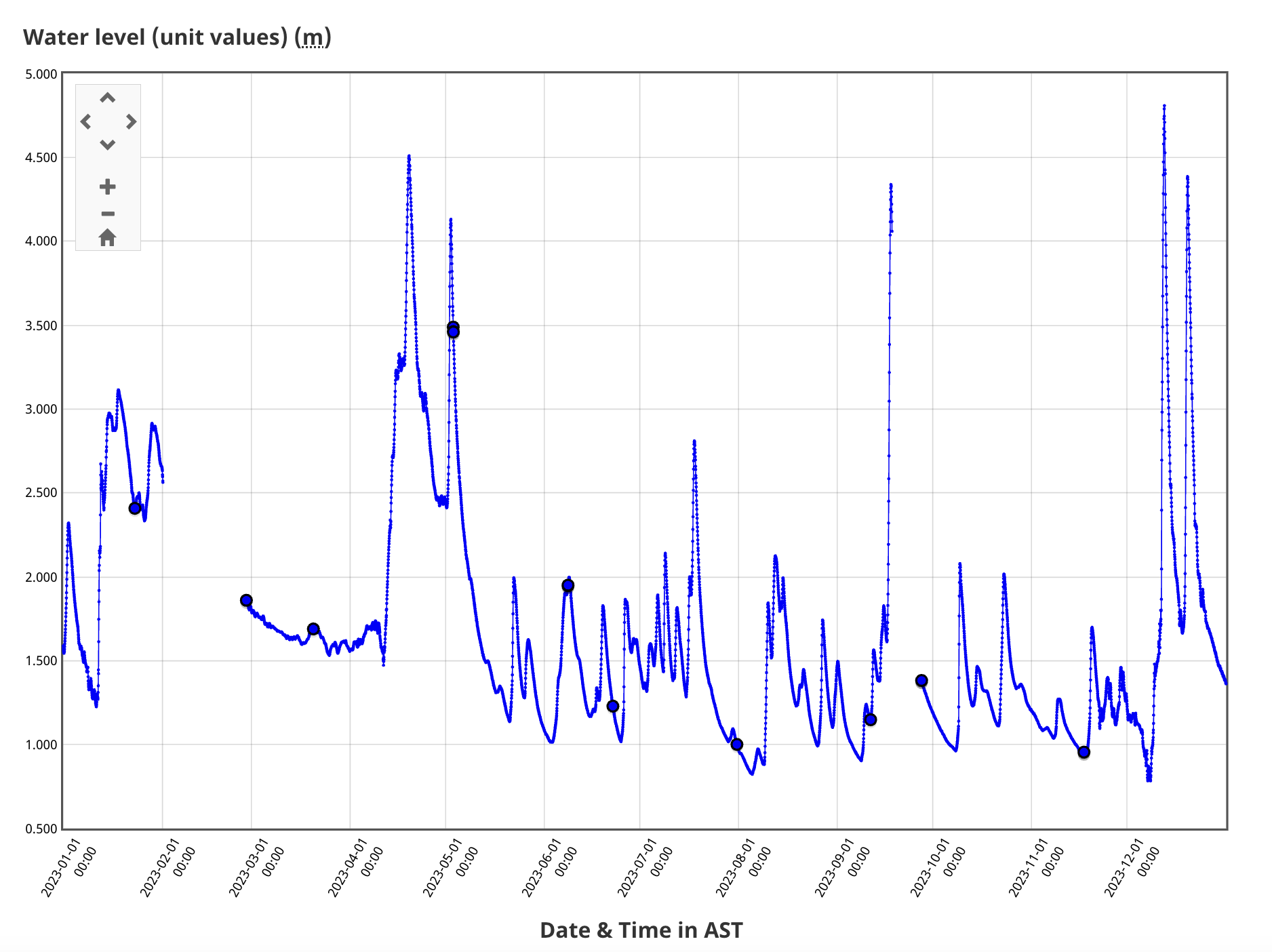
Main Southwest Miramichi River
River Reports
1.05 to 1.25 metres
Jeff J. said, "Put in at Deersdale June 13 and took out at Hayesville on the 15th. It was passable but there was a lot of rock dodging, especially early on."
1.25 metres
Carm says, "Very scratchy going with loaded canoe; lots of rocks everywhere."
1.5 metres
NRGotN says, "1.5 is great, the rapids are long and the rocks are covered but not drowned out. We were able to scrape over whenever we did hit a rock in the fast water."
1.5 to 1.88 metres
Richard says, "Day one, from Half Moon to above Slate Island, levels read 1.55 and slightly higher. Water was great. The drop at Big Louis had levelled out a little, though waves remained large and fun. Rocks elsewhere were generally covered by enough water to float you over them. Day two, to Trout Brook, levels peaked at 1.88 following a thunderstorm overnight. Conditions were not hugely different from Day one. Waves were higher and it was important to attack them straight on is avoiding them wasn't the plan. Burnt Hill Rapids were fun, with strong currents and exciting but doable waves. Day three was a short run to Norrad's Bridge with levels around 1.7. Conditions were perfect, but that stretch is affected more by wind than levels (unless very low).""
1.8 metres
esspeegee says, "The water was perfect.."
1.8 metres
Tom says, "I would say 1.5 is probably the lower limit."
2.2 metres
NRGotN says, "We had to skirt the wave trains and dodge the ledges and holes in our loaded boat, the rapids were massive. Took a sneak route on the right thru Burnt Hill, still almost swamped, but made it to shore. Exciting, but I would prefer 1.5 or so."
3.1 metres
big water all the way from mckeil to rocky brook. huge standing waves.
Map
Real-Time Levels
For real-time water levels go to the Blackville Guage (01BO001) on the Government of Canada website.
Store